Crestone Needle, Colorado

 First climbed by Albert Ellingwood and Eleanor Davis in 1918, Crestone Needle (14,197 ft) is
one of the fifty-four Colorado14ers. It sits in the heart of the Sangre de Cristo (Blood of Christ)
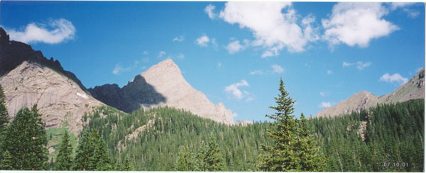
range in the southern Colorado Rocky Mountains. When viewed from the south or southeast,
Crestone Needle’s definitive profile has beckoned climbers for years. The Needle was made
famous in the 1981 book, Fifty Classic Climbs of North America by Steven Roper and Allen
Steck. There are several routes to the summit, the easiest being class 3. The other popular
route, Ellingwood Arete, is a 5.7, Grade III alpine rock climb consisting of class 3, class 4, and
several pitches of 5.7 climbing.
This expedition started
First climbed by Albert Ellingwood and Eleanor Davis in 1918, Crestone Needle (14,197 ft) is
one of the fifty-four Colorado14ers. It sits in the heart of the Sangre de Cristo (Blood of Christ)
range in the southern Colorado Rocky Mountains. When viewed from the south or southeast,
Crestone Needle’s definitive profile has beckoned climbers for years. The Needle was made
famous in the 1981 book, Fifty Classic Climbs of North America by Steven Roper and Allen
Steck. There are several routes to the summit, the easiest being class 3. The other popular
route, Ellingwood Arete, is a 5.7, Grade III alpine rock climb consisting of class 3, class 4, and
several pitches of 5.7 climbing.
This expedition started 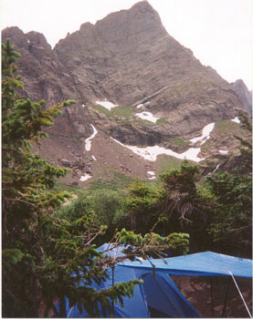 about nine months ago when I asked James Lee to teach me rock
climbing. I (Alan) had backpacked the Rockies for years and figured out that it was summiting
mountains that I really liked. So after a couple of walk-ups, I decided that mountaineering was
my calling, and summoned James to help me see this goal. The year before, my wife and I
taught James to skydive, so I figured I was in good hands.
An eleven hour drive brought us to a nice Forest Service campground outside
Westcliffe, Colorado. On the drive up highway 69, we could see the distinct profile of Crestone
Needle peeking through the foothills of the Sangre de Cristo range.
Crestone Needle seemed like a good choice for a first.......only a couple of technical pitches, lots
of cool exposure, and easy access. It was to be my first technical alpine climb after spending
several months at the gym and the crags.
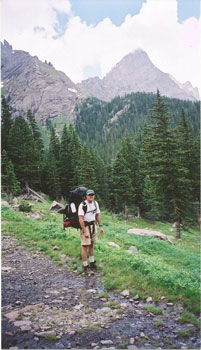
Bright and early, we left the FS campground and drove to the Colony Lakes trailhead/parking lot.
I had heard about the rough road to South Colony lakes and decided the abuse to my new Toyota
Tacoma would not be worth it........so after hiking about a mile, we caught a ride with a fisherman
to the end of the road. The South Colony Lakes area is very popular with car campers, day
hikers, and fisherman. If you get to the trailhead/parking anytime on the weekend, you should be
able to get a ride to the mountain, which will save you 6 miles of hiking up a boring mountain
road. This is definitely a four-wheel drive road
about nine months ago when I asked James Lee to teach me rock
climbing. I (Alan) had backpacked the Rockies for years and figured out that it was summiting
mountains that I really liked. So after a couple of walk-ups, I decided that mountaineering was
my calling, and summoned James to help me see this goal. The year before, my wife and I
taught James to skydive, so I figured I was in good hands.
An eleven hour drive brought us to a nice Forest Service campground outside
Westcliffe, Colorado. On the drive up highway 69, we could see the distinct profile of Crestone
Needle peeking through the foothills of the Sangre de Cristo range.
Crestone Needle seemed like a good choice for a first.......only a couple of technical pitches, lots
of cool exposure, and easy access. It was to be my first technical alpine climb after spending
several months at the gym and the crags.
Bright and early, we left the FS campground and drove to the Colony Lakes trailhead/parking lot.
I had heard about the rough road to South Colony lakes and decided the abuse to my new Toyota
Tacoma would not be worth it........so after hiking about a mile, we caught a ride with a fisherman
to the end of the road. The South Colony Lakes area is very popular with car campers, day
hikers, and fisherman. If you get to the trailhead/parking anytime on the weekend, you should be
able to get a ride to the mountain, which will save you 6 miles of hiking up a boring mountain
road. This is definitely a four-wheel drive road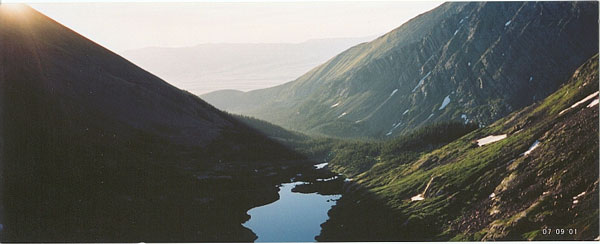 ....no way a car could make it. The road ended
and we hiked the last mile or so to the camping area near the lower of the South Colony Lakes.
Up at 4:30 AM in the dark but with a full moon. I was nervous and excited and somewhat
disorganized with gear. This would prove to be a lesson later. Too excited to eat also. The
evening before, James had scouted the approach so we started to the base in the dark. We saw
three headlamps coming from the other direction towards the base. We saw them only once
more during our climb. It took almost an hour to get to the base and the glow of sunrise began
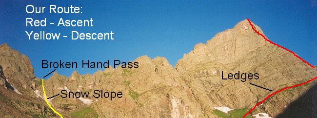
as we started up the ledges. The beginning ledges are mostly third class and gradually gains
altitude as you move towards the arete. At the arete, it turns to fourth class and we roped up for
one small section near the red knob. After the knob, we unroped and
....no way a car could make it. The road ended
and we hiked the last mile or so to the camping area near the lower of the South Colony Lakes.
Up at 4:30 AM in the dark but with a full moon. I was nervous and excited and somewhat
disorganized with gear. This would prove to be a lesson later. Too excited to eat also. The
evening before, James had scouted the approach so we started to the base in the dark. We saw
three headlamps coming from the other direction towards the base. We saw them only once
more during our climb. It took almost an hour to get to the base and the glow of sunrise began
as we started up the ledges. The beginning ledges are mostly third class and gradually gains
altitude as you move towards the arete. At the arete, it turns to fourth class and we roped up for
one small section near the red knob. After the knob, we unroped and 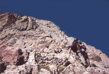 continued climbing fourth
class ledges for about 1000 ft. I had heard that some people rope up for the entire section above
the red knob but we never felt that necessary. It would take a long time to climb that mountain
if roped up the whole way. We arrived at the headwall and the first technical section. By this
time the clouds had gathered and were getting dark. My gear disorganization was becoming
evident as I could not find our FRS radios and other items we needed. Since James was leading
all the pitches, I had the pack with all the gear.
continued climbing fourth
class ledges for about 1000 ft. I had heard that some people rope up for the entire section above
the red knob but we never felt that necessary. It would take a long time to climb that mountain
if roped up the whole way. We arrived at the headwall and the first technical section. By this
time the clouds had gathered and were getting dark. My gear disorganization was becoming
evident as I could not find our FRS radios and other items we needed. Since James was leading
all the pitches, I had the pack with all the gear. 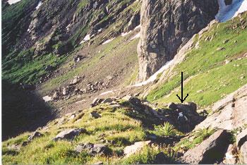 As we were setting up a belay, a solo climber
came up behind us. He waited while we did the pitch, then climbed up and passed us on the next
section. This soloist (who was a guide from a well known Durango guide service) said he would
wait for us at the summit to show us the tricky way down the back side of the mountain. The
next section (5.7 crux) is where I had a little trouble. The guide books say the crux move is
“awkward with a pack”. But I thought I could do it. Boy, was I wrong. That move was
impossible for me to do with a pack. And I didn’t have
As we were setting up a belay, a solo climber
came up behind us. He waited while we did the pitch, then climbed up and passed us on the next
section. This soloist (who was a guide from a well known Durango guide service) said he would
wait for us at the summit to show us the tricky way down the back side of the mountain. The
next section (5.7 crux) is where I had a little trouble. The guide books say the crux move is
“awkward with a pack”. But I thought I could do it. Boy, was I wrong. That move was
impossible for me to do with a pack. And I didn’t have 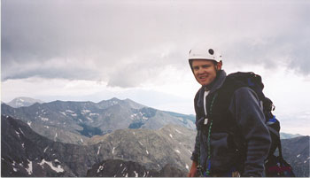 a small pack, but a Gregory Fury (2400
cu) loaded with mine and James’ gear. So in the middle of the crux move, I took off the pack,
dug for several slings, tied them together, and lowered the pack on a clown-rope tether. After
the move, I drug the pack back up and finished the pitch. God help me if I had dropped that pack
with all the rain gear, etc. By this time the clouds were really dark and we heard thunder in the
distance. After a short third class section
a small pack, but a Gregory Fury (2400
cu) loaded with mine and James’ gear. So in the middle of the crux move, I took off the pack,
dug for several slings, tied them together, and lowered the pack on a clown-rope tether. After
the move, I drug the pack back up and finished the pitch. God help me if I had dropped that pack
with all the rain gear, etc. By this time the clouds were really dark and we heard thunder in the
distance. After a short third class section 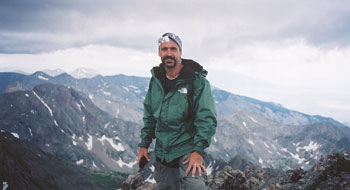 we were on the summit where it soon began to hail. We took a couple of quick pictures and we started down the backside third class route. Our “guide” must have beat feet as soon as he heard the thunder and I didn’t blame him. It hailed harder and we hunkered down under some
overhangs. Afterward, the hail began to melt and the cascading meltwater upped our
descent from class three to four. We basically followed cairns all the way down the gully and
soon reached a grassy bench. By this time I had run out of food, water, and energy. I drank
some meltwater. At the grassy bench, the cairns split, one set going down the west side of the
mountain to the valley opposite South Colony Lakes, the other set started at the top of a small
cliff opposite the gully. We started down the west side but soon realized our mistake and
climbed back up
we were on the summit where it soon began to hail. We took a couple of quick pictures and we started down the backside third class route. Our “guide” must have beat feet as soon as he heard the thunder and I didn’t blame him. It hailed harder and we hunkered down under some
overhangs. Afterward, the hail began to melt and the cascading meltwater upped our
descent from class three to four. We basically followed cairns all the way down the gully and
soon reached a grassy bench. By this time I had run out of food, water, and energy. I drank
some meltwater. At the grassy bench, the cairns split, one set going down the west side of the
mountain to the valley opposite South Colony Lakes, the other set started at the top of a small
cliff opposite the gully. We started down the west side but soon realized our mistake and
climbed back up 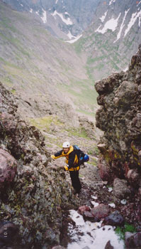 to follow the other cairns. After climbing up the small cliff, there was an
obvious trail which led to Broken Hand Pass. We arrived at the Broken Hand Pass snow slope
and started down. James slipped, slid into the rocks and apparently broke or cracked his
tailbone. This would have been safer with an ice axe. Anyway, we arrived back at camp at
around 6:00 PM, thirsty, hungry, and exhausted. We crashed immediately and slept about 12
hours. Before hiking out the next day, I found
to follow the other cairns. After climbing up the small cliff, there was an
obvious trail which led to Broken Hand Pass. We arrived at the Broken Hand Pass snow slope
and started down. James slipped, slid into the rocks and apparently broke or cracked his
tailbone. This would have been safer with an ice axe. Anyway, we arrived back at camp at
around 6:00 PM, thirsty, hungry, and exhausted. We crashed immediately and slept about 12
hours. Before hiking out the next day, I found 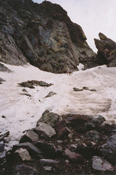 all the stuff in the bottom of my pack that I
couldn’t find on the mountain. While packing and sorting gear, James pulled out the clown rope
and laughed. Lessons learned. We hiked out, got a great meal in Westcliffe, and drove home. We originally planned to climb Humboldt Peak, then drive south and try the north face of Blanca Peak which are two other Colorado
fourteeners. However, we were tired and decided our ambitions outweighed our abilities. Oh well, we will save those two mountains for another summer.
all the stuff in the bottom of my pack that I
couldn’t find on the mountain. While packing and sorting gear, James pulled out the clown rope
and laughed. Lessons learned. We hiked out, got a great meal in Westcliffe, and drove home. We originally planned to climb Humboldt Peak, then drive south and try the north face of Blanca Peak which are two other Colorado
fourteeners. However, we were tired and decided our ambitions outweighed our abilities. Oh well, we will save those two mountains for another summer.